E-Bikes

The Devinci E-Cartier

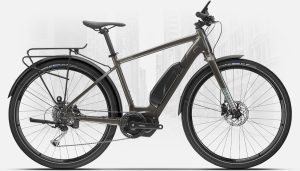
I admit that after being made into a lump by covid, it was considered a breath of fresh air to commute to work with my e-bike. I own a Quebec-made E-Cartier. The distance is one that I wouldn’t normally have time to cover on a daily basis, except this bike made it happen. This bike has a motorized assist built into the pedal assembly. And as an “assist”, it does just that; it helps you. If you stop pedalling, the bike just coasts. You do, in fact have to put effort into your pedalling, contrary to stereotypes, and yes, it can amount to a pretty good workout.

The external battery and the motor add greatly to the weight of the bike. When the battery loses its charge, you are left with lugging an unusually heavy bike. I have been pretty good about recharging the battery in a timely fashion, so power outages are rare. In normal circumstances, if you started as an out-of-shape lump like me, the bike can still give a good workout, even  with the assist. Of course, you can be in control of how much assist you want: turn down the level if you want more of a workout, or turn it off altogether. When turned off, the battery can still power the instrument display, consisting of a digital odomoeter, speedometer, and battery level indicator. It can also show how much assist you are getting.

The bike was about CAD$3000 when new. It was neither the cheapest E-bike, nor the most expensive.

The VanMoof s5 E-bike

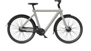
But I have heard from the New York Times that there is a new, sleeker bike in the CAD$4800 range that has much of the bulky and unsightly stuff such as cables, batteries, and even lights embedded inside the frame. So, that leaves the bike free of unsightly tech stuff. At that price point, you can expect to find a lot of innovation. For one thing, it is one of the only bikes that have automatic gear shifting. It is called a VanMoof, from The Netherlands.

But like much of what I read from NYT, it is full of breathless adoration for the shiny new bike, and not really looking at some of the downsides. For one thing, batteries have an end-of-life, and you can only charge them so many times before they need to be replaced. Now this can be a matter of a few years, but contrast this to decades for a normal bicycle with no batteries. Can batteries on the VanMoof in fact be replaced? Replacing batteries embedded deep in the frame sounds like a hell of a job. Few reviews of E-Bikes ever mention this.

If you can’t replace the batteries, we are left with a very heavy bike whose automatic shifter likely depended on the battery. In addition the innovative anti-theft system would no longer be functional; neither would the front or back lights, also embedded inside the frame. So are we expected to dispose of the whole bike? I feel that is even a concern for my E-Cartier, since even with the external battery, I have noticed that in recent models, they seemed to change the way the battery is mounted to the frame. It is possible that batteries may not be transferrable across bikes of different model years, by that reasoning.

One gets the feeling that these are not the kinds of questions we are allowed to ask. Just give the salesperson your money. This is the reason I am leery of fully electric cars as well. Once their batteries lose their ability to hold a charge, the entire car is junk. I have driven cars that are more than 25 years old. You can’t do that with any fully electric car on the market. My fear is that the same logic is being applied to the VanMoof.

Visits: 163

My first look at the Caledon Trail: a gallery

Mile zero ot the Caledon Trail is a good ways away from where I live, and not all of it is highway driving, since it is far away from the 401, the 403, the 407, and any of the “400 series” expressways. Most of the drive was through Winston Churchhill Boulevard, which gradually narrows from 6 lanes to 2 lanes as you approach Terra Cotta, where the Mile Zero marker is located. You then need to enter a dirt road with an initial sharp incline called Brick Lane and travel it to the end to see the trail.

The distance from home to the trail is further away (41 km) than the trail itself, so I drove. Since I left around 11 AM or so, it was already getting hot, and so I didn’t carry the bike in the van. Today was about seeing how easy or difficult it was to get to the Mile Zero marker, and then looking around. There were no issues, except right around Mile Zero, King St. breaks up Winston Churchhill into two sections, and you had to find the northern section to get to Brick Lane. Not that hard with a map, which I had.

The small bit of looking around I did was extremely helpful in planning my ride, when I decide to embark. It will likely be useful to divide the route into 3 sections of about 10 km each, which makes a ballpark cycling distance twice that, due to the return journey. The trail goes across main streets and towns, so it is possible to stop where I last turned back the previous day and do a new journey for another 10 or so kilometers.

More of my thoughts are below. To see the illustrations in “gallery mode”, click on a graphic, and it will behave as a slideshow. The captions are below that, and you need to click just below the caption to read the whole thing.

Visits: 75

The North End of the Etobicoke Trail

I can now say that I have travelled nearly the whole trail in halves: The southern half beginning at Markland Wood Golf Course to Turner Fenton; and the northern half starting from Turner Fenton and going to the 410 and Kennedy in Caledon.

Unlike last week’s trek, I had my cycling shoes this time. I don’t bring them to every outing, since I sometimes lose balance in them and fall. This happens a lot less since I loosened the clips, but I I’d fall off the bike about 3 weeks ago, not being able to plant both feet on the ground as I was stopping. I give myself a break and use sneakers for some outings, but for this journey I was in my cleats, and had no issues.

The middle part of the journey was the worst, going through downtown Brampton in the Queen/Main area. On my first attempt at this trail, I tended to get lost around this area, and even ended up traveling in circles. I then attempted to take the opposite direction on the trail, and ended up travelling in a different circle from the one before. Instead of encountering the same park bench, I was passing by Cardinal Leger Secondary School more than once. I called it a day, and before I drove home, I went to a drug store to find a copy of a map of Brampton. When I got home, I traced the north end of the trail through Brampton.

I know in this age of internet and cell phones, I could have used my 4G access, but actually I had used up my bandwidth, and my provider cut off the internet at 500MB instead of allowing it to go into overage. I have had this same service for a few years, and I couldn’t remember if I asked Koodoo to set it up that way, but I kept it like that and took it as a blessing in disguise, thinking that it won’t hurt to rely on a paper map.

So, I tried again the next day. This time, with the map’s help, I made it through the entire trail and crossed Mayfield Road in under 2 hours. The entire return trip was done in about 3 hours and 30 minutes, the return journey being easier.

The downtown Brampton piece of the journey involved discovering a forested area, with a sharp downhill and uphill, with a turn in between. The presence of pedestrians using the trail made me decide that I had to walk the bike.

The nicest parts of the journey were nearest to Mayfield Road. While parts of the road were packed gravel, it passed through some of the nicest forested areas I had seen in Peel Region outside of Erindale Park. I made two brief stops to stretch, drink water, and reapply suntan lotion.

Visits: 184

Cycling the Etobicoke Trail

The Etobicoke Creek Trail east of Dixie and Midway.

The original idea was to take the Etobicoke Trail from Glenforest Secondary School to Turner Fenton Secondary School. It didn’t quite turn out that way, since when I attempted the trail two days ago, I only made it as far as the 401, where the trail going underneath the 401 was under repairs until November, and was blocked by a fence. A fellow rider passing by led me to a knocked-down section of the fence barrier, leading to a part of the trail which was muddy, and possibly not the kind of trail for my bike, which had smooth tires. But I followed him nevertheless, and made it back to the paved trail on the other side. That side quickly led to west end of the Pearson Airport property, at the end of the runways. My temporary companion had disappeared by then, and I was on the part of the trail that ended up going alongside the much written about Convair Drive. On the other side of the fence of Convair was another paved road, likely South Service Road.

The south part of the Etobicoke Creek Trail, showing my many detours along Derry, Tomken, Convair, Renforth, Eglinton and Matheson, the latter to avoid the roadblock of the part of the trail running underneath the 401 on the return trip.

Being at the airport answered a small question in the back of my mind. I had seen South Service Road on the maps. Why was it called “South” when it was clearly running on the north side of the 401? Now that I see that it is on the airport side of the fence, I see it means that it runs on the south side of the airport.

Trail sign at Columbus and Derry roads. I hung a left instead of following the arrows.

I didn’t reach Turner Fenton, having taken the trail at Derry Road to Tomken. I almost ended up there, but didn’t travel under the 410/407 basket weave as I had hoped. Turning back, I retraced my steps and went back home via Convair Drive, exiting the trail. From there, I would take a sidewalk route going south on Renforth down to Eglinton. There was a very nice trail there, which made it possible to get back to Matheson Boulevard as I had intended, and re-enter the Etobicoke Trail via Sismet Road.

Weird structure observed at Pearson Airport, seen from Convair Drive.

My cycling odometer seemed to click over 78 km or so with the return trip, but a tracing of my route at walkandrollpeel.ca shows about half that (actually around 38 km, see illustration above), which when calculating average speed, makes more sense.

Visits: 66